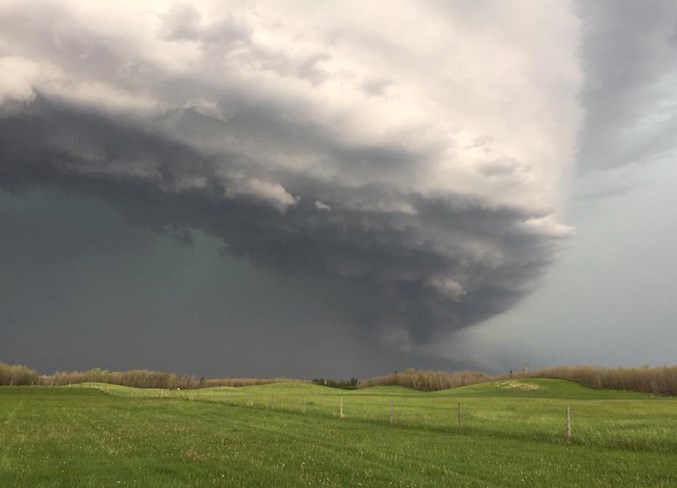
While most of the day on Saturday offered bright, sunny skies throughout most of the Lakeland, by late afternoon it appeared that was changing, and a large storm was moving through the area.
Shortly after 3:30 p.m., an emergency notification was sent out to residents, stating a tornado had touched down west of St. Paul, and recommending people in the area take shelter.
"Take cover immediately. Take all necessary precautions," read the message.
Rob Duffy, director of Emergency Management and Safety, confirmed that a tornado touched down around 3:15 p.m., southwest from Cork Hall, toward Saddle Lake.
"It wasn't down very long and was in an open field so it didn't cause any damage," said Duffy. "There was a number of trees that were damaged and an empty silo was knocked down," he added.
The Region of St. Paul Emergency Alert was then used right away to notify the public. Members of the public will only receive the notification if they are signed up to the system.
Michael Van Der Hoek is from Elk Point and has been chasing storms since 2013. He's part of Shear WX, which is a group of eight severe weather enthusiasts from Alberta and Saskatchewan.
"I've chaseď all over the Canadian prairies and in Tornado Alley in the United States," says Van der Hoek.
Van Der Hoek was right on the heels of Saturday's storm.
"For us to get a setup like this in the Lakeland is pretty rare. All the ingredients were in place for something major to happen. We saw a line of storms with inbedded supercell across the area. It was just one wicked storm after another," he says. "High winds and a massive amount of precipitation were the biggest dangers I saw with these storms. Even though they were dangerous, these storms were incredibly photogenic and brought chasers from all over Alberta and Saskatchewan. There was even a chaser that came up from the United States."
Large storms often become an intriguing topic of conversation when they happen, but with the increased use of social media, residents need to be wary of the information that is spread.
"When storms like this hit, there's always alot of misinformation on social media," says Van Der Hoek. He recommends people always refer to Environment Canada for severe weather information.
"Part of our role as chasers/storm spotters is to relay information to (Environment Canada) as the boots on the ground so they get accurate information on the storms we are on," he adds.
According to the Environment Canada weather summary on Saturday's storm for Alberta, "funnel clouds were reported near St. Paul around 3:30 p.m., however Environment Canada cannot confirm at this time that a tornado occurred in the area."
Anyone with information about funnel clouds, or wanting to report other severe weather can call 1-800-239-0484, or email [email protected] or tweet #abstorm.
Strong winds were also reported across the eastern portions of the province, with Lloydminster seeing up to 122km/hour winds. Hail was also reported in the Saskatchewan summary posted on the Environment Canada website, with Onion Lake seeing nickel sized hail.
A storm also went through the St. Paul area on Friday afternoon. Some residents reported large amounts of hail as the storm made its way through.


